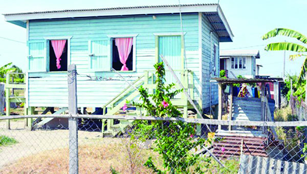
Photo above: One of the houses built for Mahaica residents who relocated to Hope Estate. Photo credit: Samuel Maughn.
By Neil Marks
IPS Guest Writer
GEORGETOWN, GUYANA (IPS) — Mrs. Doodnauth is being interviewed about the fact that the effects of climate change are what led the family to abandon their home and farmlands in the Mahaica Creek, and relocate to an area identified by the authorities.
She was clear climate change was not the reason. “And what’s the reason?”
“Too much rain,” she says. “We have never seen so much rain and floods before.”
“What is climate change?”
“I really don’t understand,” Doodnauth says with a blank stare.
It is now 10 years since extreme rainfall caused widespread flooding which devastated the coastal lowland areas of Guyana, which is below sea level and prone to flooding.
Official figures show that the 2005 floods caused an estimated US$465 million in damage, or just about 59 percent of the country’s GDP at the time. That major flood was followed by others, which resulted from severe rainfall events in the years to follow.
The families of the Mahaica Creek were the collateral damage of the extreme rainfall patterns. Even when the rains didn’t cause the banks of the creek to overflow, flooding came as a direct result of government orders.
The coastal zone of Guyana, where most people live and where most economic activity is concentrated, is cut across by a dense network of drainage and irrigation canals which are all linked to the East Demerara Water Conservancy (EDWC), a water storage canal which is the source of drinking water for the capital Georgetown, and also provides water for rice, sugar and cash crop farms during the dry season.
The problem is that the Conservancy is hemmed in by an earthen dam, approximately 67 km long, which could collapse if it takes in more than the 250 million cubic meters of water that it was designed to hold. The collapse of the dam could cause widespread flooding along the coast.
So at times of extreme rainfall, the Conservancy acts as a drainage canal, using five sluices at different locations – Cunha, Kofi, Maduni, Lama and Land of Canaan. Two of those sluices – Lama and Maduni – release water into the Mahaica River.
However, during periods of extreme rainfall, pumping the water into the Mahaica Creek aggravates the already stressful flood conditions. Unable to cope with the constant flooding, many families decided they had to leave the Creek for a new life on the coast.
In addition to the plots of land to live on, with modest houses built by Food for the Poor, they were also offered new farmlands, which they could lease.
Khemwantie Ramkissoon, 44, misses the creek. But it is not just about missing “home.” She has seen her crops – watermelons, pumpkins and other cash crops – destroyed time and time again and so she had to leave.
These days, she is unable to travel with her husband to the farm, as it often involves an overnight trip sleeping in a shack. These days also, instead of taking her line and hook to get fish for the typical evening curry, Ramkissoon now has to find money to buy fish.
For Bahawanie Basdeo, 57, a resident of Joe Hook, the creek was the only life he knew until the floods forced him to move to higher ground.
“It was terrible. When the floods come, it took away everything. Then you are forced to use your savings, but that could only last so long,” he says with a smile, but his eyes well up with tears as he speaks of his cattle killed time and time again by the floodwaters.
“The families of Joe Hook were the first to be affected, and the worst affected when water is discharged from the Conservancy into the Mahaica and Mahaicony Creeks,” said Robert Persaud, who served as Agriculture Minister when the decision of voluntary resettlement was offered.
Many families still remain in the creek. For them, the days of flooding could be over. A Conservancy Adaptation Project, the single largest adaption project in water management in the country, was developed after the 2005 floods, with the main component being another canal to drain excess water from the conservancy.
“This can also be seen in the wider context of adaptation to the effects of climate change, given Guyana’s acute vulnerabilities,” adds Persaud. A recent test of the Hope sluice was successful, the current Minister of Agriculture Noel Holder said.
Narine Singh, the chairman of a nearby local authority, believes that the new sluice will definitely reduce the possibility of flooding the Mahaica Creek.
“It will very much ease the flooding; I don’t think we will see dead cows coming down the river as before,” he says.
This story was sourced through the Voices2Paris UNDP storytelling contest on climate change.
 Pride News Canada's Leader In African Canadian & Caribbean News, Views & Lifestyle


